Thursday’s Weather : Drying Out Slowly

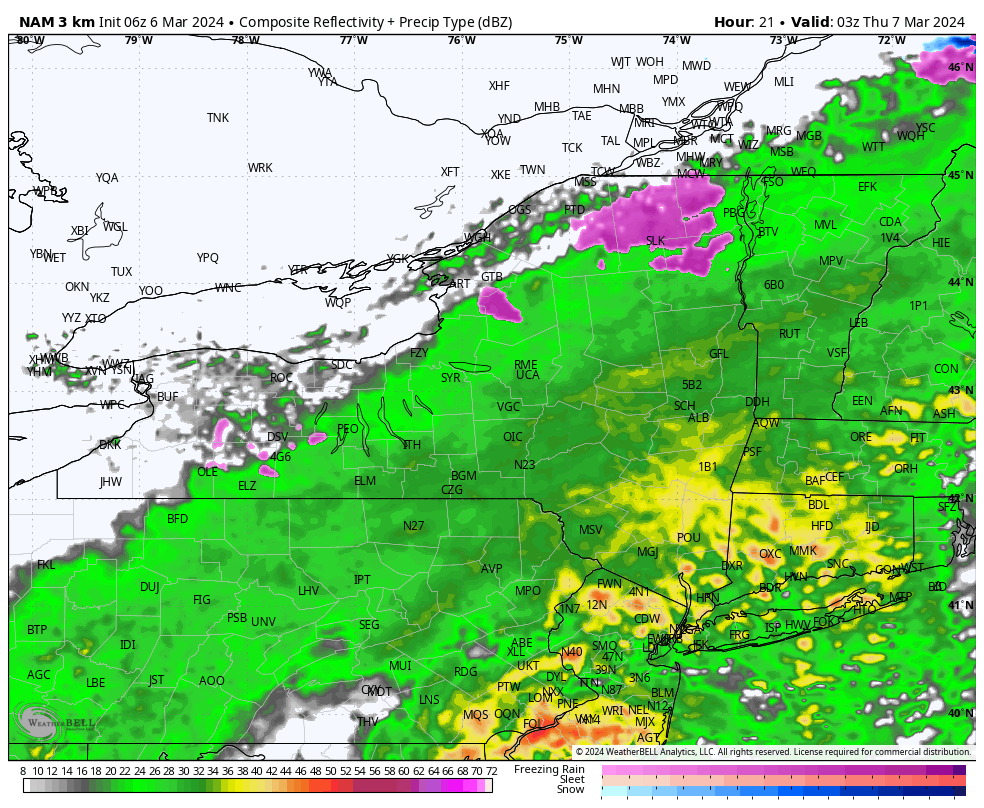
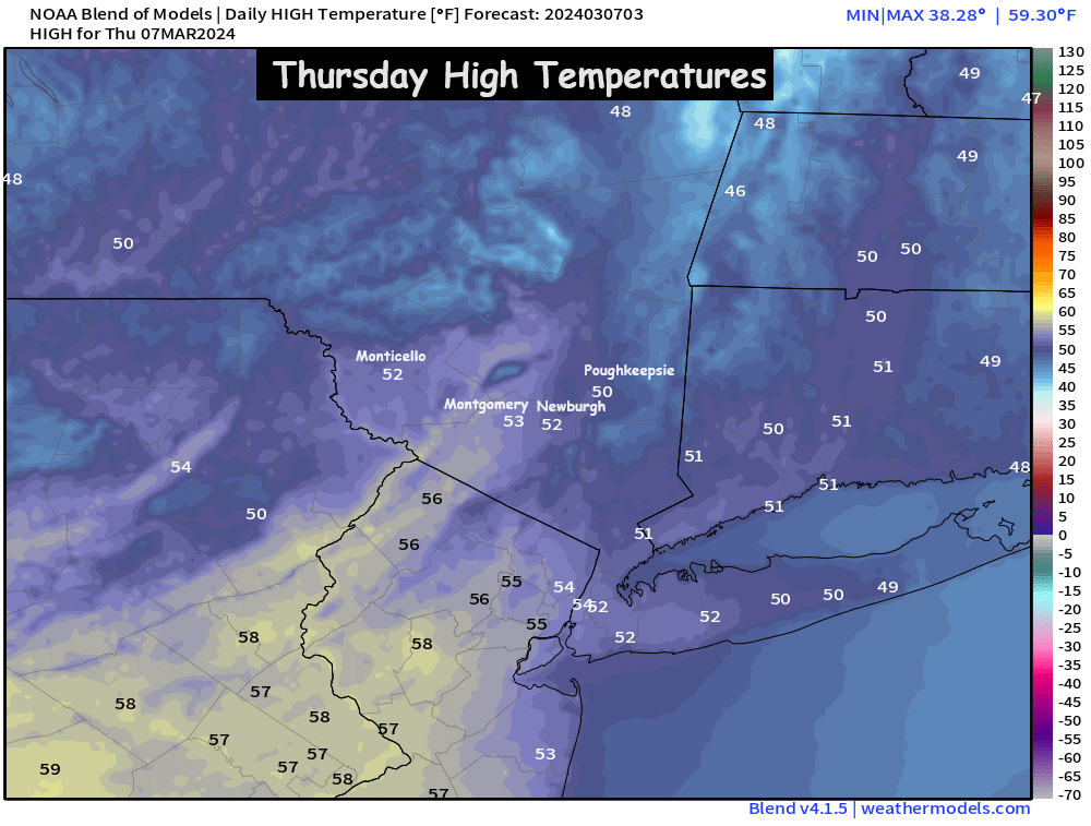
After a fully saturated Wednesday across the valley, with rainfall amounts between 1 and 2 inches on average… We’ll see the precipitation exit the Hudson Valley around sunrise on Thursday.  The steady rain should taper off before sunrise… but a few leftover showers and areas of drizzle are possible through the Thursday AM commute.  By mid-morning, the majority of the area should be mainly cloudy… but dry.  Clouds will linger through the day… with a few peeks of sun possible before sunset.  Afternoon highs on Thursday should be in the upper 40s to low 50s.

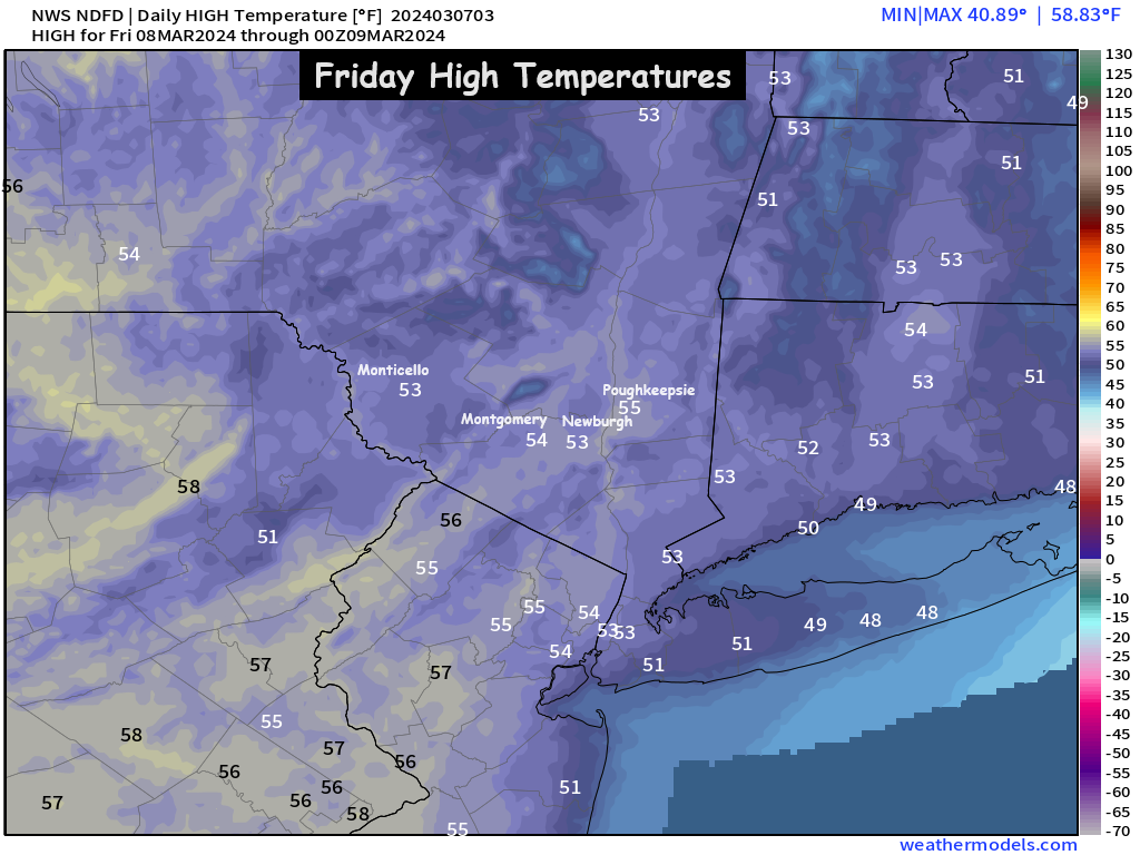
Friday looks to see some breaks of sunshine to close out the work week.  The ridge in the eastern US continues to hold, which means we’ll have a mild day on Friday.  Currently we expect a mix of clouds and sunshine… and highs in the mid 50s.

Next Storm System : Saturday Night / Sunday (mainly rain)

Clouds advance back into the region on Saturday ahead of our next storm system.

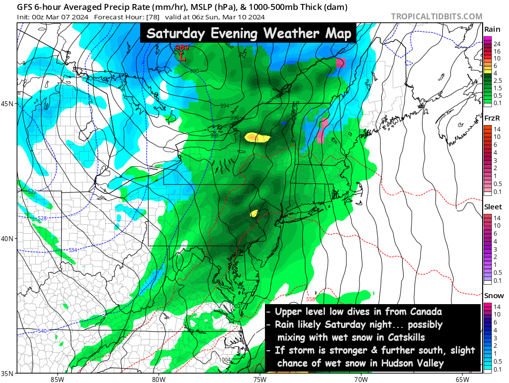
Rain is likely to develop by late afternoon or early evening on Saturday.  An upper level low pressure will drop in from Canada, and could bring enough cold air to result in high elevation wet snow, but this variable needs to be monitored in the next 2 days.  Periods of rain are then likely to fall through Saturday night, before tapering off Sunday morning.  The track and strength of the upper level low need to be monitored… but in general, around 1 inch of rain (precipitation) is expected by Sunday afternoon.

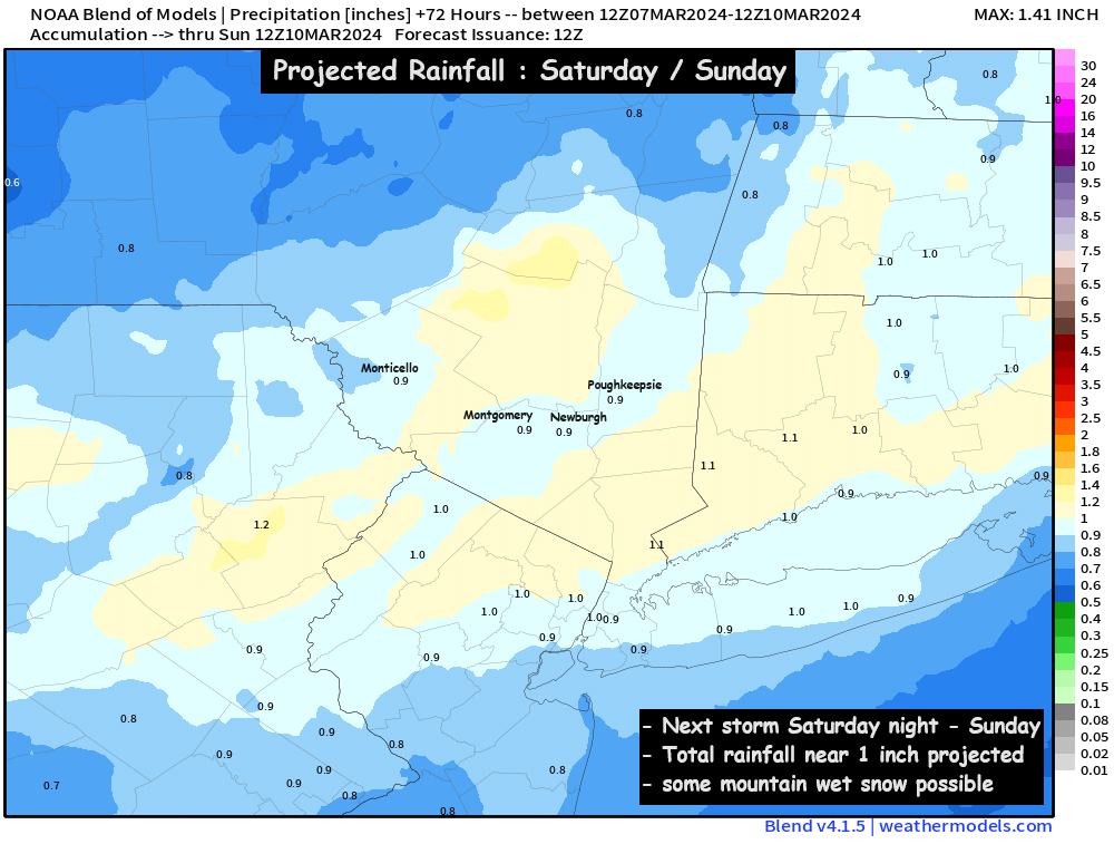
Temperatures on Sunday are likely to be in the upper 30s to low 40s… along with the roughly 3/4 to 1 inch of rainfall.  We’ll be monitoring this storm system closely in the next day or two.  Check back for more details in the coming days… otherwise, have a great Thursday!

Areas of Dense Fog followed by Heavy Rain

Our next coastal low will track NE into the region this afternoon and overnight, our ahead of it we have cloudy skies and areas of dense fog. Weather will start to go down hill by later this afternoon with period of heavy rain overnight.

Tracking the rain- areas of showers break out between noon and 2pm, widespread moderate rain overtakes the entire region between 5-7pm. Rain becomes heavy at times between 7pm and 2am, heavy rain continues to track north overnight with waves of heavy rainfall pushing into the region from the south. Steady rainfall lingers into the morning Thursday before ending between 8-10am, with only scattered showers through noontime, especially NE parts of the region.

Here’s a look at the simulated radar for overnight, showing widespread moderate to heavy rainfall across the region.

All set and done rainfall amounts of 1-3” will be likely with the highest amounts across the southern facing slopes of higher terrain.  Flood watches remain in effect for Westchester, Rockland and Putnam counties where 2”+ of rainfall is most likely to occur. Everyone stay dry, careful driving this morning with the dense fog.

Rainy Saturday

Precipitation associated with our next system will move into the region from west to east early tomorrow morning between 3am and daybreak. Initially some of this precip may start off as a period of wet snow across the Catskills, this will be limited to elevations above 1500’ with the rain/snow elevation line rising by daybreak. Showers and periods of steady rain will persist through much of the day before tapering off from west to east between 6-10PM.

Here’s a look at projected rainfall amounts and what the radar may look like tomorrow before daybreak. Rainfall amounts will be heaviest across SW parts of the region where .40-.60” may fall and lightest across NE parts of the region where rain may be a bit slower to start, where .20-.30” may fall.

Now for the silver lining, once we get through a dismal Saturday we look to pull out a decent Sunday with partly sunny skies and temps pushing into the upper 50’s with the exception of the Catskills where clouds and cooler temps may be a bit more stubborn. Here’s a look at projected temps for Sunday.


Warm Up Inbound

Seasonable Sunday, but Warm Air on the Way…

We’ll have sunshine to start our Sunday in the Hudson Valley, but we’ll watch as clouds increase through the afternoon hours. Highs on Sunday should be in the upper 30s to low 40s. Then temps will fall near freezing Sunday night… and a very weak frontal boundary will drift through the region. It could touch off a few scattered rain or wet snow showers around the Monday AM commute. Even a few areas of freezing drizzle are possible, so we have some minor concerns about icy spots Monday morning. We’ll monitor the threat through the day on Sunday and provide an update Sunday night, so you can prepare for the Monday AM commute.

However, behind the warm front on Monday, temperatures will jump quickly… pushing 50° Monday afternoon. Then an early taste of spring on Tuesday and Wednesday, with temps in the mid to upper 50s expected… thanks to the upper level ridge returning. Some scattered showers are possible on Wednesday and Wednesday night… possibly ending as a bit of snow before we have a cold end to the work week.

A possible slick start to the work week, followed by milder temps. We’ll have updates along the way. Also, the website may be down for a bit on Sunday as we continue to make upgrades. Have a great Sunday!

Bill